Coin Harvey's Resort at Monte Ne - Page 3


End of Lodge
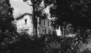
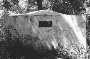
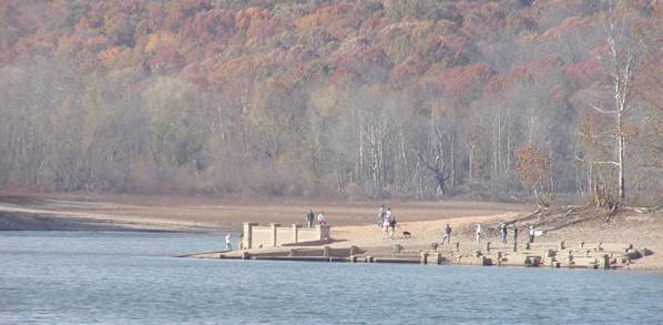
This structure was photographed in 1960 or 1961. I no longer remember what it was. The lodges were located on the high point of land above the lagoon level. I think a wooden stairway led down to the water. The bank building, the burial vault, and the bridge were located at a lower level. This view was taken from a position somewhat below the lodge.


NOTE FROM LONG AGO
On August 9, 1926, Evelyn Dodds, her older sister Lessie, and their mother Henrietta left Pine Bluff, Arkansas by automobile for a two-week vacation in the Ozarks. Evelyn was 19 years old and the only driver among them. The auto was a Ford Coupe which the sisters had borrowed from their brother, Homer. It had only enough room for three people on its single seat, so they had to leave the rest of the family at home. The three stayed over at Dover and Eureka Springs enroute to their destination, Monte Ne, near Rogers. They stayed at Monte Ne for eight days.

The journal has been transcribed just as mother wrote it, except that abbreviations have been spelled out to make it easier to read.
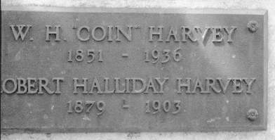
Bob Besom, son of Evelyn Dodds

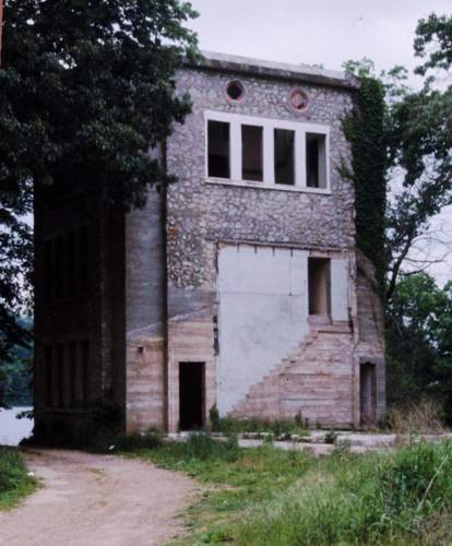
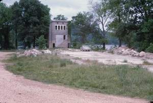
This is a sample of Evelyn's journal. Note that they had a room on the first floor of the tower.
"By the time we got back to hotel [in Eureka Springs] it was time for lunch. Served lovely meals. Soon afterwards it began raining and thundering, but did not last long, so about 2:00 we left for Monte Ne (about 40 miles). The mountain drive was perfectly beautiful, more so than any we had gone over. It had only rained enough to make everything look fresh and green. Before we arrived at Rogers we had a puncture, but Lessie and I were more acquainted with tire trouble and did not take long to get good started. However, a nice-looking gentleman stopped and finished for us. He was from Missouri, so he said, and promised to follow behind us until we got into town. But, poor man, we lost him. It was raining when we got to Rogers, but we had tire fixed and came to Monte Ne, our journey's end. Got room on 1st floor of tower. Dressed for dinner, but went to bed early, at least as soon as everything was unpacked. So cool and pleasant we overslept and was late for breakfast next morning."

Read the rest of the story in Ozarkswatch, Vol. III, No. 4, Spring 1990

Lodge Site in 1968

The photo above shows the foundation of Oklahoma Row as it appeared in 1968. The log structure had been removed before Beaver Lake was allowed to fill. The tower at the end of the foundation was attached to Oklahoma Row and I think that access to the various levels was through the main building. I don't think there are stairs inside the tower, but that would be easy to check since this area normally remains above water. My 1966 Barracuda is parked on the old foundation.

Moved Lodges

I think that the lodge was still being used for parties and programs on into the early sixties. Apparently someone owned the lodge and lagoon and maintained them for rental. Someone bought the log lodge building and moved it from the foundation to a location on private property beside the road leading to Monte Ne. Apparently the owner has not been able to have it restored.

Burial Vault

This is the burial vault of Coin Harvey and his son, Robert, in its original location on the lower land near the lagoon. The Corp of Engineers moved it to a new location above the high water mark of the lake.

Original Name Plate on Harvey Vault - 1961
Vault Plaque
Vault Plaque, 2005
Replacement Name Plate in 2005

I only saw one plaque on the burial vault and took the upper photo of it in 1961. Actually, I don't remember that I even looked on the other sides. I was using a "range-finder" 35mm camera and I didn't adjust properly for parallex. I took the lower photo on December 23, 2005. My son checked the other sides of the vault and found no other name plates. Apparently the original was removed and replaced by this new one.

July 1977 Telephoto view of the amphitheater from the old townsite area.
Amphitheater from Lodge 1977
Leeser's Telephoto View
This much longer telephoto view is courtesy of Joan Leeser from November 2005

What it might have looked like.
Might the pyramid have looked like this?

High Point in 1966 High Water 1968

The telephoto shot of the amphitheater area was made in 1977 when the lake level was low. I probably used a 135mm telephoto lens with a 2X extender for a total focal length of 270mm. The photo was taken from the area of the lodge. The telephoto view exagerates the haze of the water vapor from the lake. I have just noticed the higher wall behind the actual amphitheater area. I think that wall was the only thing above water in 1966 and it may be visible in the photo at lower left. The photo at the lower right was made in 1968 when the lake level was high enough to isolate the knoll behind the amphitheater.

PAGE 1 - The story of Coin Harvey and Monte Ne with photos of the amphitheater.
PAGE 2 - Concrete Bank Block Building and Views of the Lagoon
PAGE 3 - Lodge, Burial Vault, and Photos with the Lake at Three Levels
PAGE 4 - 1977 Lake Level marked on Old Photos, Views into the Water, Checking the Time Capsule, Related Links
PAGE 5 - Lissa Myer's Current photos of the ruins at Monte Ne: the Tower Windows, old foundations, and crowds at the amphitheater.
PAGE 6 - 2005 Views of Oklahoma Row foundation and tower with a new summary of the events of William Hope "Coin" Harvey's involvement with his Monte Ne Resort and the good roads movement. This page includes many links to other informative web sites related to Coin Harvey and Monte Ne.
PAGE 7 - Photo and map of the old townsite with a panoramic photo of some of the foundation ruins on the lake shore and across the lake to the amphitheater. There is a photo that shows the new location of Harvey's tomb. The text includes some comments from a U.S. Corps of Engineers employee who toured the Monte Ne site for the Corps in the early 60s.
PAGE 8 - Coin Harvey's Amphitheater around the Big Spring at Monte Ne. Harvey planned this to be the foyer for his pyramid or obelisk in which he planned to place a"time capsule" or museum room to hold all the important documents and marvels of civilization. However, that was never to be because he was unable to obtain financing. The photos on this page show the upper parts of the amphitheater now exposed by the dropping waters of Beaver Lake. Old photos from before the lake was built and at other times when the lake was low are included for comparison.
PAGE 9 - This page continues the amphitheater description with the south wall. Most of the south wall is under water even with the lake level at 1106 feet above sea level. The south wall may have been the planned entrance to the pyramid and time capsule that Coin Harvey wanted to build. In any case, he probably planned to build the pyramid, or obelisk, on the little hill behind the amphitheater. That little hill is an island when the lake level gets to the 1120 to 1125 range as shown in the photo posted on the previous page.
PAGE 10 - On the side of the hill behind the south wall is a tall retaining wall. The area was so covered in brush in 1961 and I was so hesitant about the possibility of trespassing that I didn't find that wall. There is a paved driveway leading from the east of the amphitheater up to the area above the wall where the railroad depot used to be. There are also panoramice photos of the view from the amphitheater back toward the old Monte Ne town site.
PAGE 11 - Selected Monte Ne Resort photos from the Rogers Historical Museum used by permission. Photo of old Monte Ne in great detail. Photos of the Bank Block when new and years later after it had been gutted by fire or weather. Photos of the amphitheater from its unfinished construction in 1928 and when that part of Beaver Lake was dry in the winter of 1977.
PAGE 12 - 2006 Wedding in the Monte Ne amphitheater. First wedding there in more than 40 years? Photo of Ann in the amphitheater in 2006 compared to a similar photo from 1977.
PAGE 13 - Photos comparing the low lake level in January 2006 with the same areas in January 2007 after the lake level rose about 20 feet.

Skipper Family Magazine
SITE INDEX PAGE
To purchase a CD of these and more old Monte Ne photos (about 50 total from 1961 to 1977) plus some recent (2005-2006) photos and a tourists' leaflet giving a brief history of the Monte Ne Resort illustrated with photos old and new and including a map showing the old Monte Ne area above and below the lake,

Send $12.50 through Rock Island Press
Or e-mail me at:
jamesmskipper@netzero.com
for other arrangements.
Historic Monte Ne CoverFor a definitive picture album/history of the resort at Monte Ne, purchase Allyn Lord's Historic Monte Ne published by Arcadia Publishing in its Images of America series.

Page 3 Revised 12/17/2005